A mine can accumulate years of inspections, sensor readings and engineering reports without making it easy to answer a basic question: what evidence supports the current assessment of risk? KorrAI is launching TRAIL to connect those records and help engineers trace an answer back to its sources.
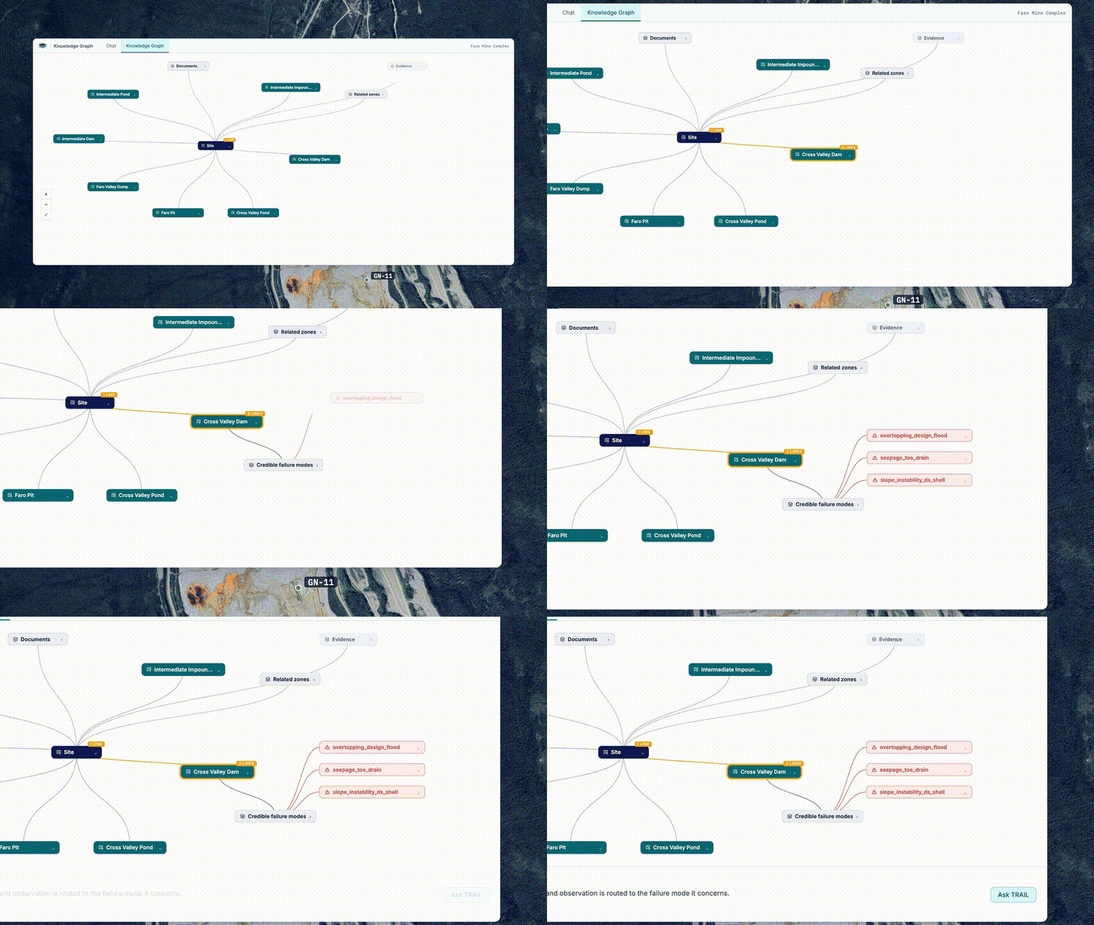
The system takes in monitoring data, inspection records, drone and satellite imagery, reports and even scanned paper. KorrAI says it organizes that material into a site-specific knowledge graph, linking evidence to the ways infrastructure could fail. Its agents then help staff investigate questions without manually reconstructing the history from separate files.
The distinction between finding an answer and substantiating it runs through the product. TRAIL is designed to cite the material behind its findings and say when supporting evidence is absent. For an engineer reviewing a risk assessment, a gap in the record can be as consequential as a reassuring measurement.
Watch the original launch video.
KorrAI describes the software as support for professional review, with engineers retaining responsibility for decisions and sign-off. That is a necessary boundary for this application: a system that retrieves relevant records does not, by itself, establish that a mine or a piece of infrastructure is safe.
The startup says TRAIL is operating at five mines in Canada and the United States. It reports $1.7 million booked in 2026, mostly recurring business, and says the spending has come from consulting budgets. Those are company-reported figures; the announcement does not provide audited financials or an independent assessment of the product’s accuracy.
The budget source helps explain the commercial pitch. KorrAI is selling a way to keep site knowledge organized and available between individual consulting assignments. If that works, the same evidence can support repeated reviews rather than being gathered again for each new question. The value would depend on both the quality of the records and how consistently the system keeps them connected.
TRAIL follows several years of work on the underlying data problem. KorrAI says it began in 2021 as a Canadian Space Agency research spin-off and spent four years developing satellite and geological processing capabilities. It now describes a team of 20 people. The company participated in Y Combinator’s Winter 2022 batch.
Its founders bring experience on both sides of the product. Rob McEwan is a geologist whose background includes Atlantic Gold. Rahul Anand has worked in enterprise connected-device technology and previously built businesses. That combination gives the team experience with both physical sites and the software used to monitor them.
The company says it is raising a seed round. It does not announce a completed financing, and its launch does not establish that the software can replace engineering judgment. Instead, the immediate proposition is narrower: make the evidence behind that judgment easier to assemble and inspect.
For a mine operator, the revealing moment may be a question TRAIL cannot answer. Showing exactly which inspection, measurement or historical record is missing would give the engineering team a concrete next step, rather than another unsupported conclusion to review.
Lorem ipsum dolor sit amet, consectetur adipiscing elit. Suspendisse varius enim in eros elementum tristique. Duis cursus, mi quis viverra ornare, eros dolor interdum nulla, ut commodo diam libero vitae erat. Aenean faucibus nibh et justo cursus id rutrum lorem imperdiet. Nunc ut sem vitae risus tristique posuere.

Built for Delaware C-Corps. Trusted by 2,000+ startups.










Copyright © Fondo (BloomJoy, Inc.)